Things to Do in Central California: Best Places to Visit
Central California stretches from the Pacific coastline to the Sierra Nevada mountains, sweeping across the Central Coast and the Central Valley. After years of wandering through this region, I’d say the best places to visit include Yosemite National Park, Big Sur, and the small coastal towns along Highway 1, each one showing off a different side of Central California. Whether you’re into national parks, wine country, or sleepy beach towns, this part of the state just doesn’t get enough credit.

Most travelers seem to skip over Central California for the flashier north or south, but honestly, that’s part of the appeal. You get granite peaks and giant sequoias, hidden waterfalls, and beaches where you won’t be fighting for towel space. The natural wonders here hold their own against any in the state. I put this guide together to highlight the things to do in Central California that actually matter, from winding road trips and wine stops to outdoor adventures for every season.
If you’re willing to slow down and get off the main highway, this region really opens up. I’ll point out the cities, hidden gems, and scenic drives that make Central California worth the detour, so you can actually plan a trip that fits your own style and speed.
Things to Do in Central California: Best Places to Visit
Planning a Central California Getaway
Central California covers coastline, farmland, and mountains, so I always kick things off by deciding which part matches my mood and priorities. Trip length and the time of year shape everything else—what roads I take, what I throw in my bag, even where I end up sleeping.
Defining the Region From Coast to Sierra
I see Central California as the stretch between Los Angeles and San Francisco, with three pretty distinct zones.
The central coast of California hugs the Pacific and features towns like Monterey, Big Sur, and Paso Robles. Inland, the Central Valley has cities like Fresno and Sacramento, both surrounded by farmland and acting as gateways to the mountains.
To the east, the Sierra Nevada mountains rise up, home to Yosemite, Sequoia, and Kings Canyon National Parks.
I usually break these three zones into separate trip legs instead of trying to mash them all together:
- Coastal zone: beaches, cliffs, and wine tasting rooms
- Valley zone: agricultural towns and access points
- Mountain zone: national parks and alpine scenery
Each area has its own rhythm, so I try to budget time for each rather than race through everything.
Choosing the Best Season for Your Trip
Honestly, timing changes the whole vibe of a Central California trip.
Summer brings crowds and brutal heat inland, especially around Fresno and Sacramento, where temps can blow past 100°F. The California coast stays cooler thanks to that stubborn marine layer fog, which usually burns off by lunchtime.
Personally, I lean toward fall and spring—the weather’s better and you won’t have to elbow your way through the parks.
Winter’s great for the coast, but mountain roads can close with snow, making some parts of the Sierra Nevada a no-go. Before I plan a winter trip that mixes coast and mountains, I always check the latest road reports—conditions can flip fast between the two zones.
How Many Days to Spend in the Region
I’d say you want at least seven days if you hope to get a real taste of the coast, valley, and mountains without burning yourself out.
This is how I usually split it up:
| Days | Focus Area |
|---|---|
| 2-3 | Sierra Nevada parks (Yosemite, Sequoia/Kings Canyon) |
| 2 | Central coast towns (Monterey, Big Sur) |
| 2 | Wine country (Paso Robles, San Luis Obispo) |
If I only have three or four days, I just pick one zone and stick with it. Trying to do both coast and mountains on a short trip usually means you’ll spend more time in the car than actually exploring.
I’ve learned that moving slower—even if it means skipping a few stops—lets me actually feel what makes Central California special.
Signature Scenic Destinations
Central California has four landscapes I think everyone should see: a wild coastline, a granite valley, groves of giant trees, and a wildflower plain. Each one brings something different, and together, they pretty much define the region’s character.
Big Sur's Dramatic Coastline
I’ve lost count of how many times I’ve driven Highway 1 through Big Sur, but honestly, the cliffs and ocean always hit the same. The road hugs the edge for nearly 90 miles, twisting and turning above the Pacific.
McWay Falls is a must-stop for me. The waterfall drops straight onto a beach you can’t reach by foot, so you take it all in from above.
Bixby Bridge is another icon. I’ve also caught sight of seals and sea lions along this stretch—those wildlife moments are part of why I always recommend Big Sur as one of the top places to visit in Central California.
Yosemite Valley and Granite Landscapes
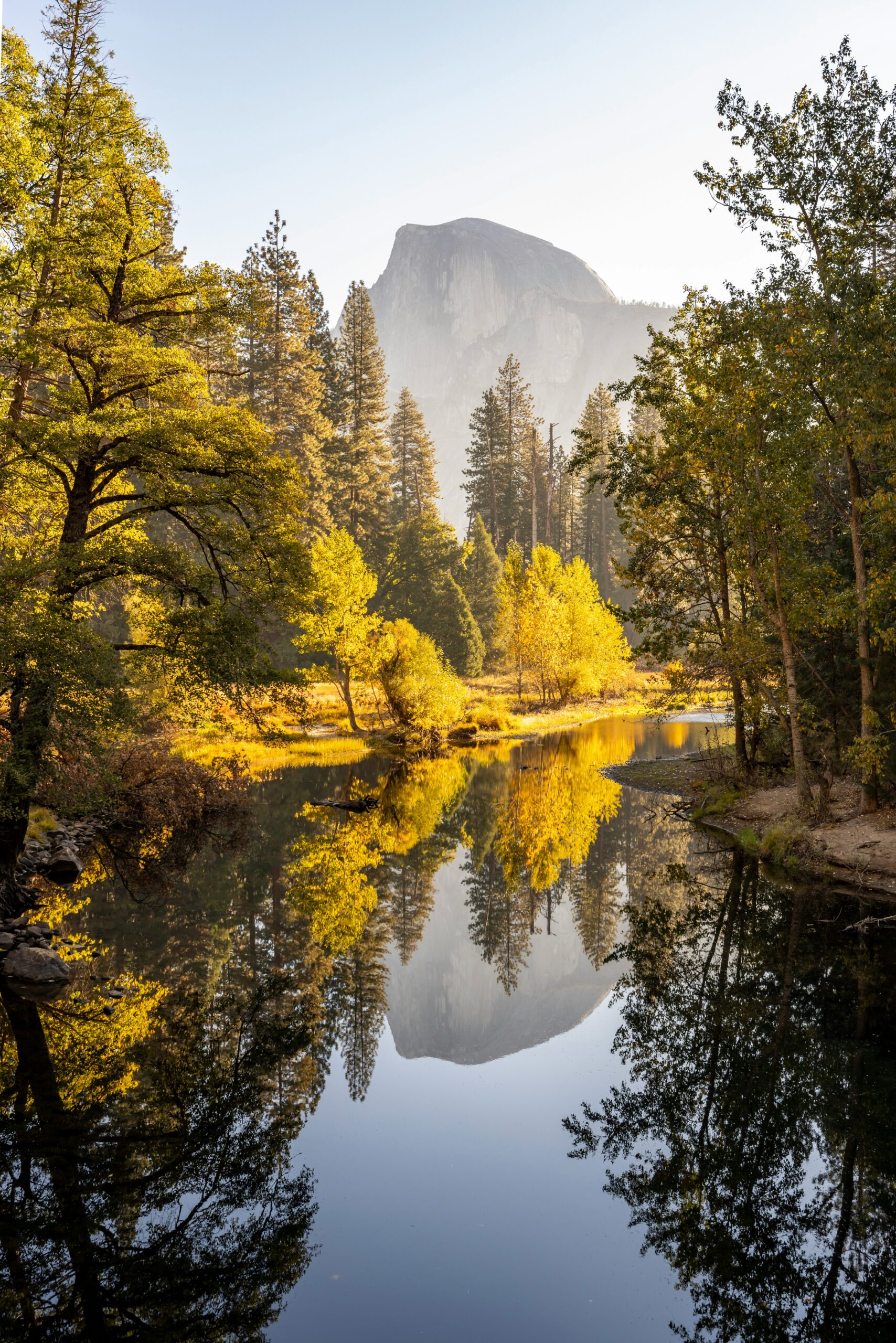
Yosemite National Park sits in the Sierra Nevada, and I always end up spending most of my time on the valley floor. Granite walls rise on both sides—El Capitan’s always got climbers on it, no matter the month.
Spring is all about waterfalls. Snowmelt feeds Yosemite Falls and Bridalveil Fall, and late spring is my favorite time to see them roaring.
The valley’s mood shifts with the seasons. Summer brings crowds and warm hikes, while winter is quiet and the granite gets dusted with snow. I’ve seen both sides, and each has its own magic in this Central California national park.
Giant Trees at Sequoia and Kings Canyon
Sequoia National Park and Kings Canyon National Park sit side by side in the Sierra Nevada, and I usually hit both on the same trip. The Generals Highway connects them (though winter sometimes shuts parts of it down).
Sequoia’s home to the General Sherman Tree—the biggest tree by volume anywhere. Standing at its base, you really can’t grasp the scale until you’re right there.
Moro Rock is my other go-to. There’s a stairway to the top, and if you catch a clear day, the views of the Sierra Nevada are wild.
Kings Canyon adds its own flavor: sheer canyon walls and waterfalls tucked among the sequoias.
Pinnacles and Carrizo Plain
Pinnacles National Park is smaller and sees far fewer visitors than the others, which I actually love. Volcanic rock formations dominate the place, and you can crawl through two talus caves here.
I always pack a flashlight for the caves. Some bat species hang out inside, and in parts, it gets pitch black.
Carrizo Plain National Monument is a different story. I time spring visits hoping for wildflowers—sometimes you’ll see the whole plain lit up in orange and purple. The monument also keeps a stretch of native grassland and wildlife alive that’s vanished from most of the Central Valley.

The Essential Highway 1 Drive
Highway 1 traces the edge of California, linking small towns, redwoods, and dramatic cliffs in one long, winding route. I tend to break the drive into four stretches, each with a different feel and pace.
Monterey to Carmel-by-the-Sea
I usually kick off Central Coast trips in Monterey—the aquarium and Cannery Row make for a mellow start before you hit the real curves.
From there, Highway 1 hugs the water down to Carmel-by-the-Sea, a quirky town full of storybook cottages and art galleries. I like to swing onto 17-Mile Drive, a scenic toll road through Pebble Beach lined with ocean views and old cypress trees.
Carmel Beach is worth a pause. The sand’s blindingly white, the water’s turquoise, and you can let your dog off-leash in certain spots.
Right south of town, Point Lobos State Reserve has tidepools, sea otters, and short trails with killer views. I usually treat this as the jumping-off point for the Big Sur leg.
Big Sur Viewpoints and Short Walks
Big Sur is where Highway 1 gets its reputation. The road tightens up and clings to the cliffs, so I slow down and plan for lots of stops.
Bixby Bridge—sometimes called Bixby Creek Bridge—is the most photographed spot on the drive. It’s 260 feet up, and since you can’t stop on the bridge itself (for obvious reasons), the nearby vista points are the way to go for photos.
Pfeiffer Big Sur State Park isn’t far and offers redwoods and river access. Pfeiffer Beach is a separate adventure—down a narrow, unmarked road. I go for the purple-tinged sand and the weird rock formations just offshore.
A bit further south, Julia Pfeiffer Burns State Park has the Waterfall Overlook Trail out to McWay Falls, where the water drops 80 feet onto the beach. It’s only a half-mile round trip—one of the easiest big payoffs on the whole drive.
San Simeon to San Luis Obispo
Past Big Sur, the road straightens near San Simeon, home to Hearst Castle. I always book a tour ahead—exploring the 165-room estate and grounds takes a while.
Just north of San Simeon, I make a point to stop at the elephant seal viewing areas near Piedras Blancas. Depending on the month, you might catch bulls fighting or pups lounging in the sun.
From San Simeon, Highway 1 rolls down to San Luis Obispo, a college town with a walkable downtown and a Thursday night farmers market that shuts down several blocks. It’s a good place to refuel and stretch out before heading farther south.
The area also leads into Edna Valley wine country, so sometimes I’ll tack on an hour for a tasting room or two before getting back on the road.
Santa Barbara and Ventura Extensions
Highway 1 eventually merges with US 101 for stretches, and I keep heading toward Santa Barbara. The Old Mission Santa Barbara, founded in 1786, is worth a stop for its gardens and architecture.
Santa Barbara's downtown State Street and waterfront really show off the city's Spanish colonial vibe, and honestly, I usually end up spending a night here just to break up the drive.
From Santa Barbara, I head south to Ventura, a smaller coastal city with a historic pier and boats that leave for Channel Islands National Park. This stretch isn't about dramatic scenery—it's more of a practical stop before you hit the LA sprawl.
Some folks treat Ventura as the endpoint for a Central California road trip since Highway 1 and the Pacific Coast Highway get a lot more urban from here on out.

Monterey Bay and Carmel Highlights
I always feel like Monterey and Carmel-by-the-Sea deserve their own time. Even though they're close, each town has its own thing going on—marine life, coastal trails, old missions. There's a lot packed into this short stretch of the Central Coast.
Monterey Bay Aquarium and Cannery Row
The Monterey Bay Aquarium sits right on the water and brings you up close to kelp forests, sea otters, and other local marine life. I usually end up spending a few hours here; the exhibits are extensive and, honestly, easy to get lost in.
Cannery Row, just outside, used to be all sardine canneries. Now it's mostly shops, restaurants, and galleries.
After the aquarium, I like walking the row since it connects directly to a paved coastal trail. It makes it easy to mix indoor and outdoor time in one go.
Old Fisherman's Wharf and Ocean Excursions
Old Fisherman's Wharf is my go-to for fresh seafood and a front-row seat to the harbor. Sea lions hang out near the docks, and you can spot them without even trying.
Several companies run whale watching trips, and the boats leave pretty regularly. Depending on the season, I've seen humpback whales, gray whales, and dolphins.
The wharf also works as a jumping-off point for fishing charters and bay cruises. It's smart to check tour schedules ahead of time since departure times shift with the tides and seasons.
Point Lobos Coastal Trails
Point Lobos State Natural Reserve is one of my favorite places to hike near the water. The trails wind along rocky cliffs and give you clear views of the Pacific—no need to walk far for the payoff.
Here's a quick breakdown of what I usually notice:
| Trail Feature | What I Notice |
|---|---|
| Cypress Grove Trail | Wind-shaped cypress trees, ocean overlooks |
| Sea Lion Point | Vocal sea lion colonies on the rocks |
| Bird Island Trail | Nesting seabirds, tide pools |
I try to get there early—parking fills up fast, especially on weekends.
Carmel Beach and Carmel Mission
Carmel Beach has white sand and clear water, with cypress trees framing the shoreline. It's easily one of the prettiest beaches I've found along this coast, and dogs can go off-leash in certain areas.
A short drive inland, the Carmel Mission dates back to the 1700s and has a stone church, gardens, and a small museum. The architecture and history make it worth a quick stop, even if you don't linger long.
For more to do in Carmel-by-the-Sea, I like to walk through downtown for galleries and restaurants, or head out to Carmel Valley for wine tasting when I'm tired of the coastal fog.
Historic Estates, Missions, and Local Culture
Central California's history really comes through in its Spanish missions, lavish estates, and the immigrant communities that shaped unique towns. I think these spots tell you as much about the region as the coastline or wine country ever could.
Hearst Castle and Neptune Pool
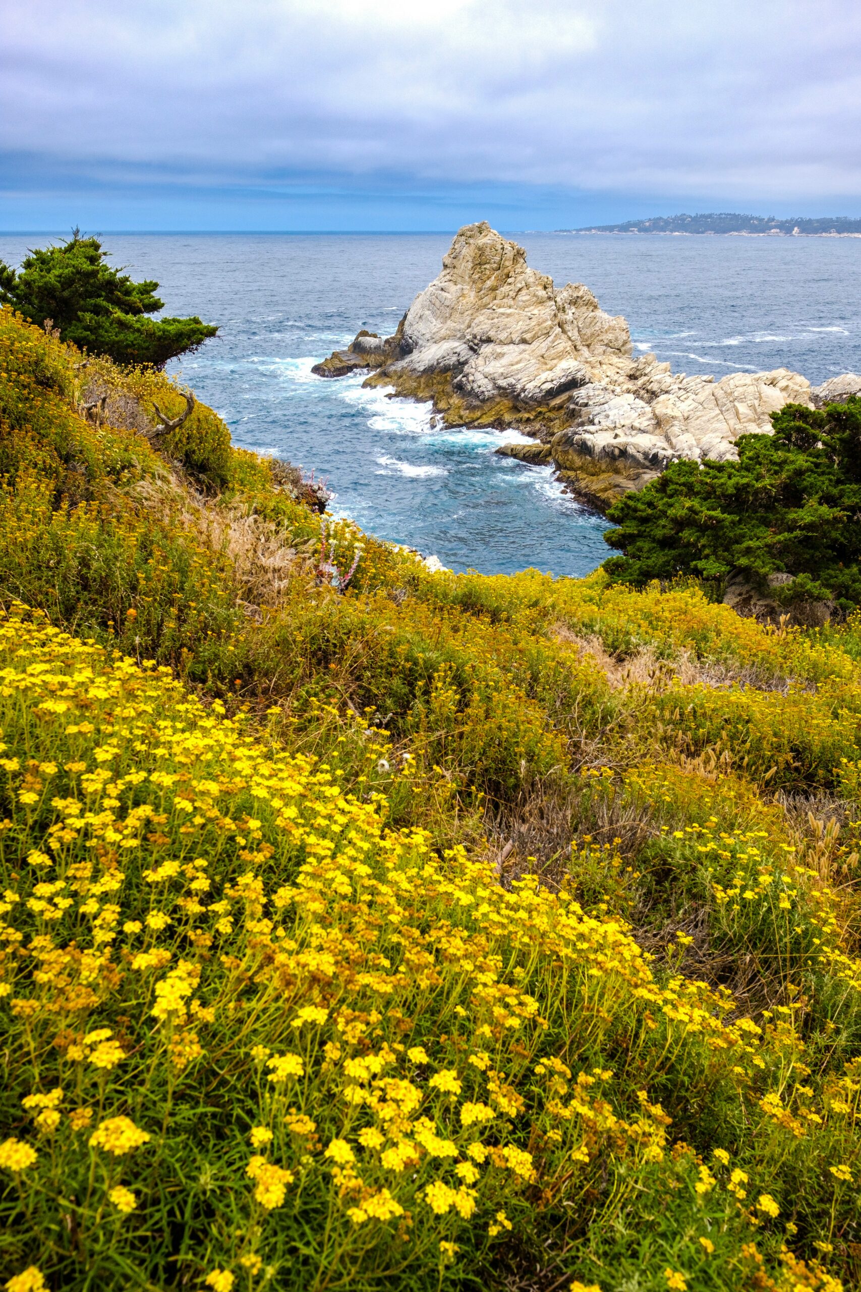
Hearst Castle stands out as one of the most impressive estates I've toured in the U.S. Newspaper magnate William Randolph Hearst built it above San Simeon, and it took nearly 30 years to finish.
The Neptune Pool is my favorite part. Those Greco-Roman columns and marble statues surround a pool that once hosted Hollywood's elite back in the day.
It's best to book tickets ahead of time—tours sell out, especially during peak season. You can pick from several options, each focusing on different parts of the estate.
Mission San Luis Obispo de Tolosa
I always make a point to stop at Mission San Luis Obispo de Tolosa when I'm in the city center. Founded in 1772, it's the fifth California mission and the city grew up around it.
The mission sits right on the main plaza, so it's easy to pair with other downtown stops. I appreciate that it's still an active parish, not just a tourist site.
Inside, there's a small museum with artifacts from the mission's early days. The nearby creek and plaza make for a nice walk before or after visiting.
Solvang's Danish Heritage
Solvang feels like one of the most unique cultural stops in Central California. Danish immigrants founded the town in 1911, and you can still see the Danish heritage in its half-timbered buildings and windmills.
I always go for aebleskiver, those Danish pancake balls dusted with powdered sugar, at one of the bakeries. It's a simple treat, but it really captures the town's vibe.
The Hans Christian Andersen Museum is another spot I like. It covers the author's life and ties into Solvang's broader Danish identity.
Solvang is close to Santa Ynez, so I usually add some wine tasting in the valley to the itinerary.
Quirky Stops in San Luis Obispo
SLO's downtown is packed with offbeat attractions that break from the usual historic sightseeing. Bubblegum Alley gets the most attention: it's a narrow alley with walls covered in decades of chewed gum from visitors.
The Madonna Inn is another spot I never skip. Every room has a different theme—think caveman rock walls or over-the-top pink Victorian décor—and the on-site bakery is worth a stop even if you're not staying there.
Honestly, these stops give SLO a personality that's pretty different from the more formal mission and estate tours elsewhere in the region.
Coastal Towns Worth Lingering In
I've spent enough time along this coastline to know these towns reward a slower pace. Each one has its own character, from dune-backed beaches to volcanic rock outcrops to Victorian-era main streets.
Pismo Beach and Avila Beach
I think Pismo Beach is one of the most versatile stops on the coast. The pier and Pier Plaza are great for a sunset stroll, and I've spotted monarch butterflies in the eucalyptus grove during winter.
South of town, Oceano Dunes offers OHV driving on sand dunes, which is pretty rare for the California coast—vehicles are actually allowed on the beach here.
Avila Beach is just a quick drive away and feels calmer, tucked into a sheltered cove. I think it's better for swimming and relaxing, compared to Pismo's windier, more open beach. Both towns have seafood spots right on the water, and honestly, I'd set aside time for at least one meal with a view.
Morro Bay and Morro Rock
Morro Bay is all about Morro Rock, that 576-foot volcanic plug at the harbor entrance. I always stop for a close look—it's one of the most recognizable natural landmarks on this stretch of coast.
The town is a working fishing harbor, so fresh seafood is everywhere. I've had some great meals at the waterfront restaurants along the Embarcadero.
Morro Bay State Park, just south of downtown, adds:
- A saltwater marsh and estuary for birdwatching
- Kayak and paddleboard rentals for exploring the bay
- A golf course with bay views
- Hiking trails through eucalyptus groves
I'd plan for at least half a day here to see both the rock and the state park.
Cambria and Moonstone Beach
Cambria feels quieter and more residential than Morro Bay or Pismo Beach. I like the pine-covered hills and how the town blends into the landscape instead of taking it over.
Moonstone Beach, the main coastal stretch, has a boardwalk running along the bluffs. I've walked it at different times and always found it good for tide pools and spotting sea otters offshore.
The name comes from the moonstones people used to find along the shore, though I wouldn't count on finding many now. Cambria's downtown has some galleries and shops, but for me, the beach is the main attraction.
Capitola Village
Capitola Village sits further north in Santa Cruz County, and it stands out from the rest with its colorful, tightly packed waterfront buildings. Those pastel facades along the beach make it one of the more photogenic towns on the coast.
I've spent time browsing little shops and grabbing seafood at restaurants right on the esplanade—most have water views. The beach itself is small but perfect for a laid-back afternoon.
Capitola's Wharf, one of the oldest in California, stretches out into Monterey Bay and gives you a nice vantage point back toward the village.

Wine Country and Farm-Focused Escapes
Grapes and produce have shaped a lot of my travel through this region. Each wine district here brings its own personality, shaped by soil, coastal fog, or the area's ranching past.
Paso Robles Tasting Rooms and Vineyards
I’ve discovered that Paso Robles has well over 200 wineries spread across 26,000 acres, and honestly, I never seem to run out of new tasting rooms to try. Rhône-style wines rule here, but every estate has its own thing going on—I can taste it from glass to glass.
The town still feels like a rural, cowboy-friendly place. I like to pair my tastings with contemporary wine country meals at whatever local restaurant catches my eye.
Plenty of producers here practice sustainable viticulture. I usually ask about their methods when I visit, since it shapes both the wine and the landscape I’m driving through.
Santa Ynez Valley Villages
I head south into Santa Ynez Valley when I’m craving Pinot Noir. Coastal fog drifts through this east-west valley, and I notice how it creates distinct growing conditions across the region, supporting around 42 varietals.
My favorite stop? Los Olivos—a tiny town where I taste Grenache wines that producers are reviving with fresh energy. Solvang’s close by, with its Danish-settlement vibe and quirky architecture.
Highway 246 connects these villages for me. Each one has its own pace, from mellow tasting rooms to busier main streets.
Edna Valley and San Luis Obispo Wine
Near San Luis Obispo, I always stop in Edna Valley for those wind-swept vineyard views. I go to Tolosa and a few other wineries here, honestly as much for the scenery as the wine.
This area ties into a bigger sustainability push that I’m pretty into. The SLO Sustainable Wine Trail features around 50 wineries along a 70-mile stretch of Highway 101, linking San Luis Obispo and Paso Robles.
I use this trail when I want to focus on eco-conscious producers. It also gives me a simple route between the two wine regions.
Santa Maria Food and Wine Stops
I always think of Santa Maria for its ranching history and distinct barbecue style. I make time to eat here before or after any wine tasting.
The Santa Maria Wine Trolley makes it easy to see multiple tasting rooms. It offers hop-on, hop-off access to some of the region's top tasting rooms, so I don’t have to worry about driving myself.
Santa Maria works well as a base. From here, I can reach Edna Valley, Los Olivos, and other Central Coast spots without long drives in between.

Water, Wildlife, and Beach Activities
The Pacific Ocean along Central California’s coast supports a ton of marine life, and I’ve noticed that timing and location really determine whether you’ll spot gray whales, elephant seals, or sea otters. Beyond wildlife, the water itself offers kayaking, surfing, and fishing—stuff I consider pretty much essential for any coastal trip.
Whale and Marine Mammal Viewing
I’ve had the best luck spotting gray whales during their winter and spring migrations—usually December through April. Humpback whales show up more reliably in summer and fall, often feeding surprisingly close to shore.
San Luis Bay stands out to me for sightings, since operators there report daily whale and dolphin encounters all year.
I always make time for the elephant seal rookeries, where I can watch these massive animals hauled out on beaches, especially during breeding season (December to March). Sea lions and sea otters are easier to spot; I usually see them lounging on piers or floating in kelp beds just offshore.
Kayaking and Paddleboarding
I go for calm coves and estuaries when I paddle, since the open ocean can turn rough fast. Morro Bay and Elkhorn Slough are two favorites for flat water and close-up views of otters and shorebirds.
Paddleboarding works best for me when the wind is light, the swell’s down, and the tide’s rising—basically the same as kayaking. I always check local conditions before heading out, since fog and afternoon winds can change things quickly along this coast.
Most beach towns have rental shops, so I don’t bother hauling my own gear unless I plan to paddle somewhere remote.
Surfing, Swimming, and Fishing
I’ve surfed a bunch of breaks along the Central Coast, and the water stays cold all year, so a wetsuit isn’t optional. Beginners usually do better at beaches with gentler waves, while more experienced surfers chase the reef and point breaks up north.
Swimming conditions shift from beach to beach; I always check for rip currents and lifeguards before jumping in. Some coves are calm enough for families, but others have strong currents I’d rather steer clear of.
Fishing here is a blast, whether I’m on a pier, a charter boat, or just casting from the surf. You’ll find rockfish, halibut, and salmon, depending on the season and spot.
Responsible Wildlife Observation
I keep my distance from elephant seals, sea lions, and other marine mammals, since getting too close can mess with their behavior and honestly, puts me at risk too. Federal guidelines say to stay at least 50 yards away from most marine mammals, on land or in the water.
Birdwatching adds another layer for me, since the wetlands and estuaries pull in herons, pelicans, and migratory shorebirds. I bring binoculars instead of creeping closer, which lets me watch without being a nuisance.
I also skip feeding any wildlife, since it messes with their instincts and makes them rely on people. I stick to marked trails and viewing areas to help protect both the animals and the fragile habitats they count on.

Hikes, Parks, and Mountain Adventures
Central California gives me access to coastal bluffs, granite peaks, and alpine lakes—sometimes all in the same weekend. Whether I’m a casual walker or feeling ambitious, there’s terrain for pretty much every skill level.
Easy Coastal Hiking Trails
I always recommend Montana de Oro State Park to anyone craving ocean views without a brutal climb. The bluff trails stretch for miles along dramatic cliffs, and I rarely deal with crowds, even on weekends.
Pfeiffer Big Sur State Park is another solid pick. The trail to Pfeiffer Falls is short, shaded, and manageable for families with young kids.
I also like the coastal paths near Cambria and Cayucos. These routes stay mostly flat, which is perfect when I just want scenery without a workout.
Sierra Nevada Day Hikes
Yosemite National Park is still my go-to for granite formations and waterfalls. I think the Mist Trail to Vernal and Nevada Falls is the most rewarding, though it does climb steadily.
Sequoia National Park feels completely different. Walking among giant sequoias—especially the General Sherman Tree—never gets old.
If you want more Sierra Nevada trail options, Kings Canyon and Devils Postpile add volcanic formations and river canyons into the mix. I try to start early to dodge the afternoon heat and crowds at the trailheads.
Camping and Horseback Riding
I’ve camped in both state parks and national forest land all over Central California, and the variety still surprises me. Here’s a quick breakdown of what I usually consider:
| Activity | Best Locations | What I Pack |
|---|---|---|
| Tent Camping | Sequoia, Yosemite, Montana de Oro | Bear canister, layers, water filter |
| Horseback Riding | Yosemite stables, Big Sur ranches | Closed-toe shoes, sunscreen |
| RV Camping | Established campgrounds near park entrances | Full hookups, reservations |
Horseback riding through Big Sur’s coastal trails gives me a slower way to soak in the scenery. I’ve also booked guided rides near Yosemite Valley, which are great for beginners who want a bit of structure.
Mammoth Lakes Summer and Winter Activities
Mammoth Lakes works as a year-round spot in my book. Summer brings hiking, mountain biking, and fishing at alpine lakes like Twin Lakes and Lake Mary.
Winter’s totally different—then it’s all about skiing. Mammoth Mountain usually has reliable snow, and the terrain fits both first-timers and seasoned skiers.
I plan separate trips for each season since the activities don’t really overlap. The elevation changes fast from the valley floor, so I always pack layers, no matter when I visit.
Hidden Gems and Flexible Itineraries
Central California really rewards travelers who mix famous stops with quieter alternatives, and honestly, the region’s layout makes it easy to build a trip around whatever time you’ve got. Whether I have a day or a week, the coast, mountains, and valleys all connect naturally along a handful of routes.
One-Day Coastal Sampler
If I’ve only got a single day, I stick to a compact stretch of the central California coast instead of trying to see everything.
I start early in Monterey, walking the waterfront before the crowds show up. Then I drive south toward Big Sur, pulling over at a few coastal viewpoints for photos instead of committing to some epic hike.
My usual stops look like this:
- Monterey: harbor views and a quick coffee
- Bixby Bridge: just a short stop for a photo, no hiking
- One Big Sur overlook: I pick just one, so I’m not rushing
This pace keeps the day relaxed. I’d rather linger at three places than race through five and remember none of them.
Three-Day Coast and Wine Route
With three days, I pair coastal scenery with inland wine country, since the regions sit close enough to avoid long drives.
Day one covers Monterey and Big Sur, pretty much like the single-day plan but with time to actually walk a trail or two. Day two, I head to San Luis Obispo, a town I like for its walkable downtown and easy beaches.
Day three, I go inland to Paso Robles and spend the afternoon at two or three wineries—no need for a marathon. I’ve learned that fewer stops with more time at each one makes for a better experience than cramming my schedule. This route also works in reverse if I’m starting from the south near Santa Barbara.
Weeklong Coast-to-Mountains Journey
With seven days, I split my time between the coast and the Sierra Nevada—honestly, a week feels just right to see both without that frantic, rushed vibe.
I spend the first three days on the coastal route I mentioned above, then swing inland toward Yosemite National Park. The drive itself takes hours, so I just let that be its own travel day. Trying to cram in sightseeing on top of it? Not worth it.
In the mountains, I divide the rest of my days between Yosemite and Sequoia National Park. They're close enough to each other that this plan actually makes sense:
| Days | Focus |
|---|---|
| 1-3 | Coast (Monterey to San Luis Obispo) |
| 4 | Travel day inland |
| 5-6 | Yosemite National Park |
| 7 | Sequoia National Park |
I skip extra stops once I’m up in the mountains. The drives alone take up more of the day than you'd think.
Low-Crowd Alternatives to Major Stops
Some of the most visited spots in Central California have quieter counterparts nearby, and I usually recommend at least one substitution per trip.
Instead of the busiest sections of Big Sur, I sometimes detour to Carrizo Plain National Monument, which sees far fewer visitors despite its striking landscape. Sure, it’s not a direct substitute for Big Sur’s scenery, but honestly, the solitude out there is something you just can’t find along the main coastal route—especially when everyone’s out for summer break.
If someone’s set on wine tasting but wants to avoid the crowds in Paso Robles, I’ll look for smaller, family-run vineyards tucked a few miles off the main road. Santa Barbara’s wine country has a similar vibe if you know where to look.


